Our state is the most altered landscape in the country. The
land that was prairie was plowed over, and what was once wetland filled in, to
create the vast swaths of corn and soybean monocultures that represent our
state to the world. What was once a diverse and ever-changing habitat for
thousands of different species has become a tedium whose sole function is to
support one species at the expense of all others. Any insect or mammal that
dares feed at our exclusive trough—covering 93% of our state—must be exterminated, with extreme prejudice.
The land is unrecognizable. And with every acre converted
from crops to human dwellings it becomes even more so, as we shape the land to
suit our needs, Developers install gentle slopes and channels to tell the rainfall
where to go, and scrubby little ponds to capture the water that doesn’t get
diverted into our rivers. Every inch of land is remade as rich topsoil, the
product of thousands of years of life growing and decaying, is scraped away and
replaced with plastic-meshed turfgrass atop the hard-packed clay soil that
remains. |
Iowa River near Amana
|
But one thing has proved difficult to significantly alter: our network of rivers and waterways. Try as we might to dam them, divert them, channel them, constrain them, we are ultimately no match for the water's collective power. Their sometimes extravagant twists and turns may look terribly inefficient to our human sensibilities when viewed from a satellite, but their routes are etched in the land according to the properties of the land itself as water seeks the path of least resistance through softer earth or around geologic formations. The river's inevitability will erode that which it encounters, sometimes cutting off some of those crazy curls to make a new channel, leaving an oxbow lake or, in some cases, shunting a piece of Illinois onto the west side of the Mississippi.
As I travel virtually down the Iowa River, into the
Mississippi and beyond, I grow to appreciate more and more how rivers shaped our
history: how we traveled, where we settled, what we bought and sold, the
borders and scenery of towns, cities, and states. I see the green trees edging
the winding blue lines, quickly fading into the patchwork quilts of
agricultural fields, and wonder what those patchworks looked like before.
 |
Mississippi River near Cairo, IL
|
Often the rivers run directly through cities and towns, like
our own Iowa City. In some places, the rivers have been embraced and made the
centerpiece of their communities, with scenic riverwalks and places to touch
the water, launch kayaks, drop a fishing hook or wade in the clear shallows.
Our muddy, sometimes frothy, occasionally unruly Iowa River must
have been an indelible part of our history, but it is difficult to visualize. Our
trails and parks that overlook the river seem so distant, separated by scrubby
brush or rocky rip-rap. I’ve seen images showing steamboats on the river—steamboats!
Can you imagine? Where did they dock, who did they carry? What did the bridges
that traversed the waters look like? How did people use the river a century
ago, two centuries ago?
Much of the infrastructure from that era is gone, but the
river remains. We may not travel along it, to the Mississippi and beyond. We
may not ever touch its waters--or want to touch its waters!--but it is still a part of our community.
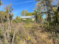
I only recently learned about a somewhat neglected piece of our city's history: the Montgomery-Butler House, built before the Civil War and currently nestled in a wooded part of Waterworks Prairie Park. What intrigued me was the fact that Martin Montgomery, who built the house, also ran a ferry across the river in that area. Who used the ferry? Where were they going, whence were they coming? Was there a road that would become Dubuque Street present at the time, lacking a bridge? Much of the evidence of the lives that were lived are lost to history, but we have a small stone structure to remind us...and the river.


